Beehive Basin, Big Sky, Montana
- Peter D. Bouloukos
- Aug 10, 2017
- 3 min read
Lee Metcalf Wilderness, Spanish Peaks, Big Sky, Montana
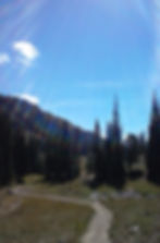
This trail is just over 3 miles long, but begins at just under 8,000' feet and reaches roughly 9400'. It gives access to high country scenery in a short climb. The trail climbs steeply in areas, but you are rewarded with a high meadow in a beautiful cirque, framed with rugged rock walls. Beehive Basin, Big Sky, Montana has a wide variety of alpine wildflowers within weeks after the snow melt. It's also a great place to hike and Spring ski but be careful!!! Wildlife abounds on this hike so keep your head up! On one hike a mother and baby moose were eating in a tree right on the trail!

Do not expect solitude on this hike; it is very popular due to its accessibility and of course the amazing scenery. It's an excellent way to access and experience the Spanish Peaks of the Lee Metcalf Wilderness. I hope to hike from the Basin to Lava Lake at some point with of course an overnight camp or two!

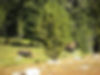
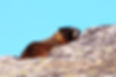
Next, the first mile is private land so stay on the trail and respect the landowners' property and posted signs. At 1.2 miles: Turn left at the junction with the North Fork Tie Trail. 1.4 miles: Watch for marmots and pikas in the huge rock pile. For views of Lone Peak, head to the trail at the far side of the rock pile in order to avoid disturbing the critters! I have never done this hike in the evening but I would LOVE to see sunset from the rock out-cropping over Lone Mountain at Big Sky Resort, Montana. Maybe that's next!!!!

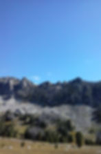
Now, there are several stream crossings which can be jumped easily during runoff. You will enter the Lee Metcalf Wilderness around 2 miles. The normal turnaround point is at just over 3 miles where small lake and creek exist. During runoff the water can appear to drop off the mountain kind of like an infinity pool!


Although the 360 degree views are great from the lake, for an even better picture of the surroundings, continue up along the cascading creek, then follow a faint trail left to the top of the small rocky bluff above the lake at about 3.5 miles. There is also a small pond above the bluff most never experience.

Total Elevation Gain = 1545' Start = 8000'
Highest Elevation = 9395' at the lake. This hike is roughly 6.8 miles round-trip as described above. It is family friendly and well marked. Rocks exist on the trail, one reason I suggest keep your eye's up as much as possible especially when you have bad ankles or knees due to potential wildlife. I would rate this hike as moderate on the easier side. With the start at 8000' it is alpine terrain lower in oxygen even for people from Gallatin Valley.